Grid Automation & AI
Advanced utility robotics and deep-learning diagnostics engineered to eliminate live-line maintenance risks.
Autonomous live-line utility drone wash systems.
Airborne line installation and removal mechanics.
Automated computer vision surface fault tracking.
Sub-surface joint diagnostics and automatic report systems.
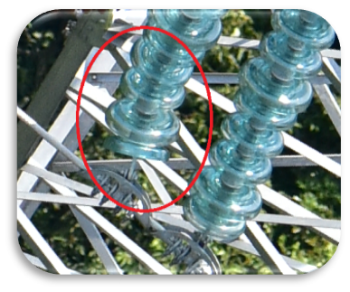
🚁 Drone Insulator Washing System
Our proprietary airborne wash payload enables rapid, live-line cleaning of high-voltage insulators without grid de-energization. By operating entirely via remote automation, we keep maintenance crews safely clear of active electrical fields.
- ✔ Pressure Matrix: Precision fluid stream engineered to protect structural component integrity.
- ✔ Live-Line Safety: Rated for high-voltage environments with isolated airborne airframes.
- ✔ Operational Speed: Cleans structural elements significantly faster than standard ground crews.
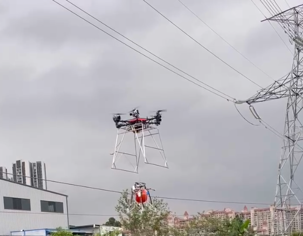
Marker Ball Installation
& Uninstallation System
Universal Aerospace Solutions delivers an aviation-grade precision hardware platform engineered specifically for overhead transmission lines and grounding shield wires. By achieving fully automated attachment and detachment mechanics, our robotic aerial payloads replace high-risk manual installations with safe, software-guided field deployments.
🧠 Flight Control Ready AI
Our robotic payload systems operate completely decoupled from basic manual assumptions. Equipped with a built-in AI powerline identification system, the mechanism actively processes real-time spatial video matrices.
This edge-computing framework calculates conductor distance, sway variables, and attachment clearance metrics, sending high-frequency guidance correction feeds directly back into the aircraft's primary flight control system.
📜 Governing Aviation Mandates
Our mechanical deployment architecture is engineered and field-validated to fully comply with global safety levels and warning visibility criteria:
- • ICAO (Annex 14): Meets international civilian aviation rules for structural obstruction markings.
- • FAA Advisory Circular 70: Aligns with strict North American airspace marker parameters.
- • CAAC MH5001: Compliant with specialized airport airfield technical lighting and markings.
- • IEEE 516 Standard: Fully certified for live-line maintenance proximity tolerances and clearing methods.
Safety – The Ultimate Value Driver
Our automated utility engineering platform completely eliminates human risk by moving field technicians out of active electrical hazard points into safe ground control operation networks.
1. Eliminating "Human-on-the-Line"
Removes the requirement for traditional bucket truck placements, conductor-riding buggies, and dangerous high-altitude climbing maneuvers.
2. Mitigating Helicopter "Line-Strike"
Eliminates standard manned helicopter operations that fly dangerously close to transmission strings, reducing structural impact accidents.
3. Reducing Electrostatic Discharge
Isolated mechanical composite materials intercept electrostatic induction shocks, completely shielding core electronics from active line grid degradation.
📊 Drone Powerline Inspection Services
Universal Aerospace Solutions offers a variety of UAV turnkey solutions engineered across highly specialized industrial applications. We provide total visibility into your electrical infrastructure—ranging from detailed, methodical multi-rotor drone inspections to wide-area VTOL fixed-wing powerline and asset patrols.
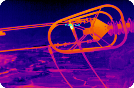
Visual & IR Thermography
The primary function of our fleet is to capture high-definition video images using synchronized video and specialized Infrared (IR) cameras. This configuration allows field crews to isolate hot-spots, thermal degradation anomalies, and insulation defects instantly.
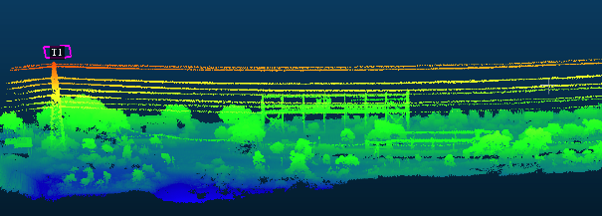
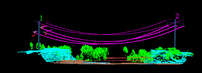
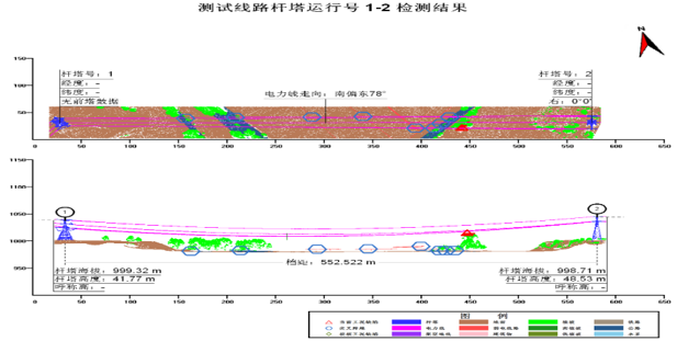
LiDAR 3D Point Clouds & Sag Analysis
Utilizing industry-standard DJI M300 airframes carrying high-end Riegl Mini VUX1-UAV or Velodyne LiDAR sensor suites operating at a safe stand-off distance of 70 meters from the line, we construct hyper-detailed 3D power structure models and calculate precise sag tolerances.
Vegetation Encroachment & Special Payloads
Our laser scanning arrays easily pierce canopy layers to capture tree limbs penetrating protected right-of-way spaces. This adaptive framework also tracks clearance buffers, coordinates automated foreign object removal tasks, and supports active X-ray line splice imaging on the same operational flight profile.
Advantages of UAV Utility Inspections
- 1. Mature and Reliable Technology: Proven hardware and stabilized systems built to manage critical utility grid tracking environments.
- 2. Diverse Inspection & Surveillance: Multiple distinct diagnostic sensor payloads can be carried out simultaneously during a single system launch.
- 3. Helicopter-Quality Data Results: Visual capture resolutions and data densities are completely comparable to high-altitude helicopter operations.
- 4. Proven Mission Operational Efficiency: Established as an accelerated, high-yield vehicle format for remote asset delivery and validation.
- 5. Highly Cost-Effective: Maximizes budget allocations by cutting mobilization logistics, heavy fuel expenses, and crew down-times.
Our System Integration Metrics
- • Fully Integrated Inspection System: Sensors, flight log metrics, and data diagnostics link seamlessly together for uniform analytics.
- • Highly Stable Performance Profile: Built-in multi-axis vibration dampening protects data capture feeds against line electromagnetic interference.
- • Lightweight and Portable Framework: Rapid setup footprints enable two-person field engineering teams to launch from any terrain.
- • Enormous Corporate Customer Base: Trusted and validated by a broad global portfolio of electrical utility managers and network stakeholders.
- • Competitive Acquisition & Operation Cost: Engineered to provide the industry's lowest total data collection cost per line-mile.
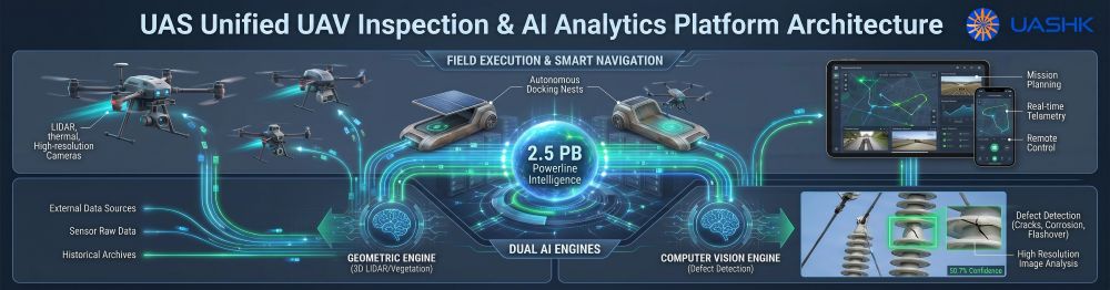
Turnkey UAV Powerline Inspection Services
& Autonomous Analytics Fleet Architecture
Universal Aerospace Solutions delivers an interconnected, aviation-grade hardware and cloud processing platform engineered for wide-area grid networks. By merging automated multi-rotor sorties, high-density LiDAR terrain scans, and real-time computer vision networks, we replace legacy manual field loops with verified enterprise data.
The Ultimate Value Driver: Empirical Training vs. Lab Simulation
Why typical off-the-shelf AI analytics software tools experience domain failure loops when deployed onto live high-voltage corridors.
❌ Off-The-Shelf AI Platforms
Standard commercial software platforms train their neural networks using synthetic 3D renders, clean lab-generated anomalies, or artificial simulation loops.
When exposed to actual corridors, these models fail or trigger endless false alarms because they cannot handle complex backgrounds, lighting variations, lens flares, lens artifacts, or unpredictable real-world weather patterns.
💎 UAS Empirical Core Architecture
Our Inspection Vision-AI Module is built entirely upon a mathematical training data matrix derived from real-world field photography.
Because our networks have analyzed millions of raw field images captured over actual operational line miles, they instantly isolate corrosion, fractures, and component wear despite intense background noise or bad field illumination.
Proven Network Trajectory & Operational Scale
Point clouds, thermal arrays, and RGB images.
300k km transmission, 600k km distribution.
Executed safely over precise RTK coordinates.
Verified via semantic cloud segmentation.
Domain Competency Matrix: UAS vs. Tech Giants
| Platform | Ingestion Scale | Defect Precision | Hardware Link |
|---|---|---|---|
| 💎 UAS Engine | 12.19M+ infrastructure photos & 2.5PB+ point clouds. | Over 90% accuracy across specialized hardware failures. | Native Integration: Linked to uncrewed drone docks. |
| Off-the-Shelf Large Language Models | Billions of general web text files; zero grid telemetry vectors. | Frequent domain hallucinations; misses fine structural wear. | None. Operates strictly inside standalone cloud software layers. |
| Major OS Giant | Broad generic imagery arrays (consumer, landscape, text documents). | Requires manual labeling; fails against noisy tower backdrops. | Requires custom webhooks to speak with flight controllers. |

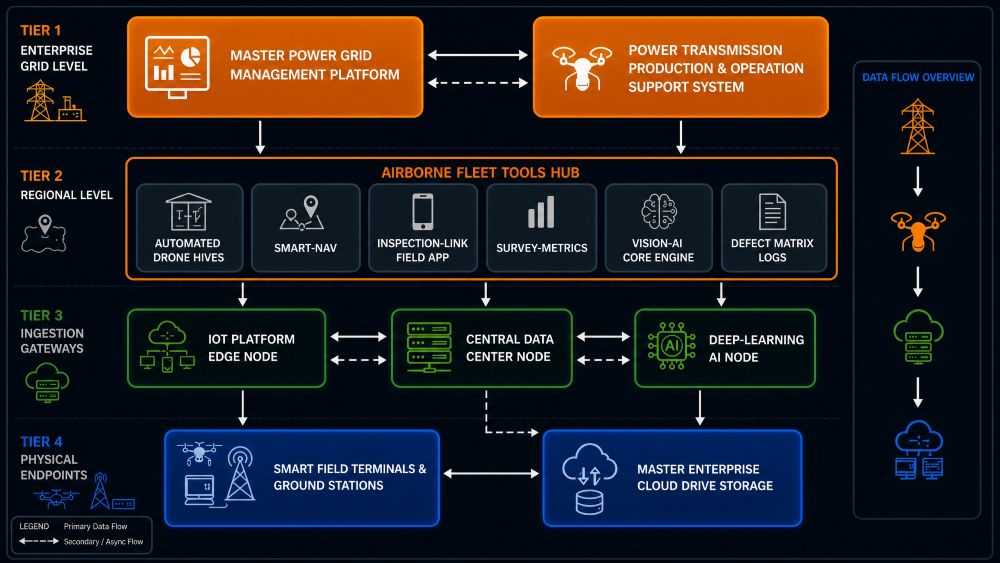
The Closed-Loop Utility Inspection Pipeline
Our infrastructure platform coordinates data flow smoothly from the physical airspace down to enterprise cloud assets. By unifying advanced flight frames, dense sensor matrices, and automated cloud computing backend modules, we deliver a rapid, touchless workflow that turns raw data into actionable maintenance work orders.
AI-Assisted X-Ray Diagnostics
for Overhead Line Compression Joints
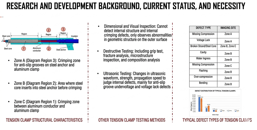
The Necessity of Sub-Surface Machine Learning
Overhead transmission tension clamps form the mechanical and electrical backbone of high-voltage power grids. However, internal structural defects stay completely hidden from traditional inspection routines.
Universal Aerospace Solutions deploys non-destructive radiographic imaging paired with computer vision neural networks. Our software eliminates human error, automates fault localization, and enables utilities to transition to true predictive grid maintenance.
Limitations of Traditional Testing Methods
Why standard utility field inspection metrics fall short, and where computer-vision x-ray analytics provide absolute grid safety.
🔍 Dimensional & Visual
Strictly limited to the exterior clamp shell. It cannot detect internal structural shifts or sub-surface crimping defects. It only spots surface anomalies after crimping is complete.
⚠️ Destructive Testing
Includes grip tests, fracture analysis, microstructure tracing, and material composition analysis. Highly limited because it destroys the sample and is restricted to post-accident investigations.
📡 Ultrasonic Wave
Measures ultrasonic intensity and velocity changes to evaluate hidden errors. Primarily limited to locating missing anti-slip groove compressions or voltage lack anomalies.
System Segmentation & Defect Architecture
Our machine learning framework segments hardware components into discrete diagnostic zones based on verified failure characteristics.
Processed Machine Vision Reporting Case Studies
Actual testing outputs and data logs generated automatically by our platform's image analytical processing models.
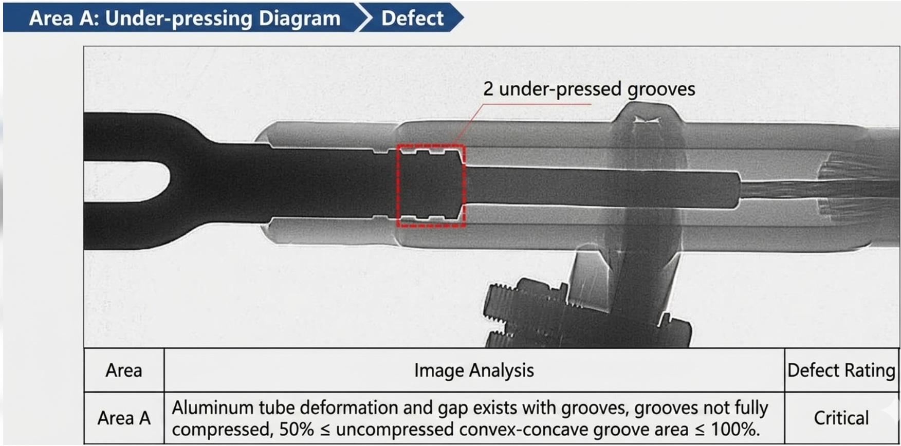
Zone A: Missing Crimp Compressions
Diagnostic Log: Clearance gaps tracked between the outer aluminum sleeve casing and the internal anchoring block. 2 separate grooves left completely uncompressed by the installation tool, presenting a major risk to line gripping capacity under high line loads.
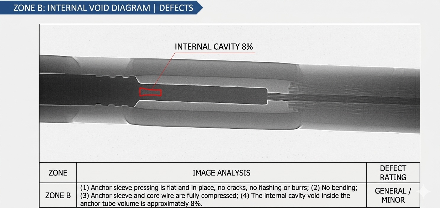
Zone B: Internal Core Void Inclusion
Diagnostic Log: Outer anchoring sleeve dimensions verify as flat, uniform, and straight with zero cracks or surface flashing. However, internal sub-surface modeling flags a localized internal air gap cavity measuring ~8% volume inside the anchoring core sleeve. Logged for regular tracking.
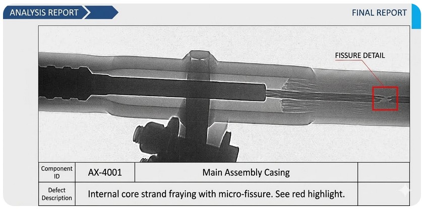
Zone C: Core Strand Fraying & Fissures
Diagnostic Log: (Component ID: AX-4001). Computer vision processing models tracking the transition matrix identified deep sub-surface line breakage along the wire core strands. Active micro-fissure expansion threatens complete structural grounding failure under high vibration or wind events.
Integrate Automated Image Diagnostics Into Your Fleet
Our automatic processing software runs natively inside standard ground workstation setups or securely syncs with field-deployed aerial drone data acquisition streams. Contact our team to schedule an engineering demo or request a whitepaper brief.